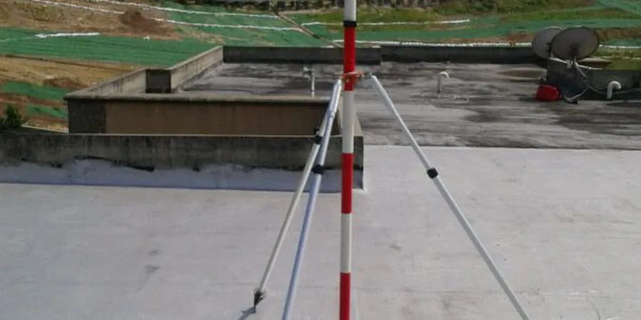
Setting up a solid monitoring plan in Wexford starts with deploying a network of calibrated instruments directly into the cut and its surroundings. Inclinometer casings run vertically into the ground to detect lateral deflection, while vibrating wire piezometers track pore-water pressure changes at multiple depths—critical data when you are working mere meters from the River Slaney or the quay walls. Total stations and automated prisms mounted on adjacent structures complete the picture, feeding sub-millimetre readings to a central logger that our engineers access remotely. This hardware backbone, combined with an understanding of Wexford’s layered glacial tills and occasional soft alluvial pockets, transforms raw tilt and pressure figures into actionable risk thresholds before a shoring system ever approaches its design limit. For deeper profiles where SPT refusal is expected, integrating findings from spt-drilling helps validate the stratigraphic model against the real-time deformation data.
In Wexford’s tidal-influenced clays, real-time piezometer data is not just a check—it is the trigger that determines when to pause excavation and when to proceed.
Local considerations
The coastal humidity and persistent rainfall that define Wexford’s climate create a scenario where instrumentation must survive continuous dampness while delivering laboratory-grade precision, because a rain-soaked logger that misses a critical displacement reading can cascade into a shoring failure within a single shift. Excavations near the Crescent Quay or along the town’s medieval street pattern face the added risk of undermining unreinforced masonry foundations, where even 5 mm of differential settlement can open cracks that propagate through party walls. The observational method prescribed in Eurocode 7 relies entirely on the premise that the monitoring system will detect anomalies before they become irreversible; if the piezometer filter becomes clogged with the fines that are abundant in Wexford’s silty subsoil, the loss of pore-pressure visibility could mask the rapid approach of hydraulic uplift in the base of the cut. Our protocol therefore includes fortnightly in-situ checks, redundant sensor placement at each critical horizon, and automated comparison against the numerical model’s predicted deformation envelope, ensuring that a false sense of security never takes hold on site.
Frequently asked questions
How much does a geotechnical excavation monitoring programme cost in Wexford?
Monitoring programmes in Wexford typically range from €680 for a short-term standalone piezometer installation with manual readings, up to €2,220 for a comprehensive automated system that includes inclinometers, real-time total station monitoring, and weekly engineering reports over a critical excavation phase. The final cost depends on the number of instruments, the monitoring duration, and the required reporting frequency.
What are the warning signs that an excavation in Wexford’s soils is becoming unstable?
Accelerating lateral deflection rates in the inclinometer profile—especially if they exceed 2–3 mm per day—combined with a sudden equalisation of pore-water pressure readings across multiple piezometer levels, often indicate that the passive resistance in the toe is degrading. Surface cracks appearing beyond the 45-degree influence line from the base of the cut are another late-stage indicator that the monitoring system should have flagged much earlier through tilt and settlement data.
Why is continuous monitoring necessary instead of taking weekly manual readings?
In Wexford’s tidal environment, pore-water pressures can swing by several kilopascals within a six-hour cycle, and a weekly reading would completely miss these peaks. Continuous automated logging captures the full envelope of pressures and deflections, allowing the engineering team to correlate deformation with specific triggering events—such as a spring tide or a heavy rainfall—rather than guessing from a handful of disconnected data points.