The ground beneath Wexford town centre tells a different story from the soils out toward Rosslare. The town core rests on stiff glacial tills, while the harbour margin transitions into soft estuarine silts and clays deposited by the River Slaney. That contrast matters when shaking arrives. Seismic microzonation maps these variations block by block. The team recently compared shear-wave velocity profiles from Ferrybank with readings taken near Clonard, and the difference in amplification potential was immediate. A MASW survey provides the Vs30 backbone, but microzonation layers in the stratigraphy, groundwater, and basin geometry that generic site class tables miss. For engineers working under Irish National Annex to Eurocode 8, the output feeds directly into ground type determination and spectral shape selection. We also pair it with seismic refraction lines where bedrock depth is uncertain, a common situation where the Cambrian greywacke drops away beneath the Quaternary cover.
Two sites 300 metres apart in Wexford can show a factor-of-two difference in spectral acceleration at 0.2 seconds, purely due to buried channel geometry.
Methodology and scope
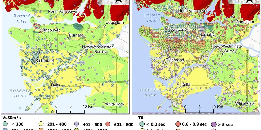
Wexford sits at roughly 52.3 degrees north, on a passive margin with low regional seismicity, yet the Irish National Annex to I.S. EN 1998-1:2005 still requires site-specific hazard assessment for consequence class CC2 and CC3 structures. The last widely felt event was the 1984 magnitude 5.4 Lleyn Peninsula earthquake, which rattled windows along the east coast. Seismic microzonation integrates 91 borings, CPT soundings, and surface-wave arrays to build a three-dimensional ground model. A
CPT test through the Slaney alluvium captures pore pressure response and thin sand lenses that standard SPT misses, while laboratory
triaxial testing on undisturbed Shelby tube samples defines strain-dependent stiffness degradation curves. The final zonation map divides Wexford into response domains: stiff till plateaus with Vs30 above 400 m/s, softer alluvial corridors where Vs30 drops below 200 m/s, and transitional zones at the town's western edge. Microtremor array measurements confirm the fundamental site period shifts from 0.1 seconds on rock to over 0.6 seconds on deep soft clay.
Local considerations
The geophone array spreads across a Wexford car park at dawn, 24 vertical-component sensors in a linear pattern, a sledgehammer striking an aluminium plate every two metres. The crew runs three spreads per site to stack ambient noise recordings with active-source shots. Without this data, a building on the quayside might be designed to the same ground type as one on the granite outcrop near Spawell Road. The consequence is resonance mismatch: a four-storey moment frame on 18 metres of soft clay can experience storey drift amplification well beyond what a Type C assumption predicts. The microzonation study catches that before the footing concrete is poured. In the harbour area, where liquefaction assessment has flagged loose saturated sands at 4–6 metres depth, the site response analysis couples excess pore pressure generation with cyclic strain softening, a scenario that standard response spectra ignore entirely.
Frequently asked questions
How much does a seismic microzonation study cost for a site in Wexford town?
Microzonation study costs in Wexford typically range from €4,110 to €13,420, depending on the number of measurement points, the array configuration required, and whether laboratory dynamic testing is included for site-specific modulus degradation curves.
What ground investigation data is needed before a microzonation study can begin?
The study requires borehole logs with SPT N-values, CPT soundings where soft soils are present, and existing geotechnical cross-sections. We integrate this with surface geophysics, calibrating shear-wave velocity profiles against stratigraphic boundaries at each borehole location.
How does microzonation differ from a standard site investigation for seismic design?
A standard investigation assigns a single ground type to the site. Microzonation maps the spatial variation across the property, capturing basin effects, lateral stratigraphic contrasts, and changes in fundamental period that a single borehole cannot resolve.