With over 20,000 residents and a history stretching back to Viking times, Wexford sits on a varied geological palette of Ordovician slates, Cambrian quartzites, and extensive glacial tills deposited during the last ice age. What many developers first notice is the flat terrain around the harbour, but the subsurface can shift from stiff lodgement till to soft alluvial silts within a few hundred metres. For structural engineers working in County Wexford, determining the average shear wave velocity in the upper 30 metres (VS30) is the starting point for seismic site classification under Eurocode 8. The MASW method gives us a non-invasive way to map that velocity profile without sending a drill rig onto every corner of the site. In practice, we often pair the MASW array with a few SPT boreholes to calibrate the dynamic properties against standard penetration data, especially where the till transitions to weathered bedrock.
A VS30 below 180 m/s can shift a Wexford site from ground type C to D, doubling the seismic design acceleration under Eurocode 8.
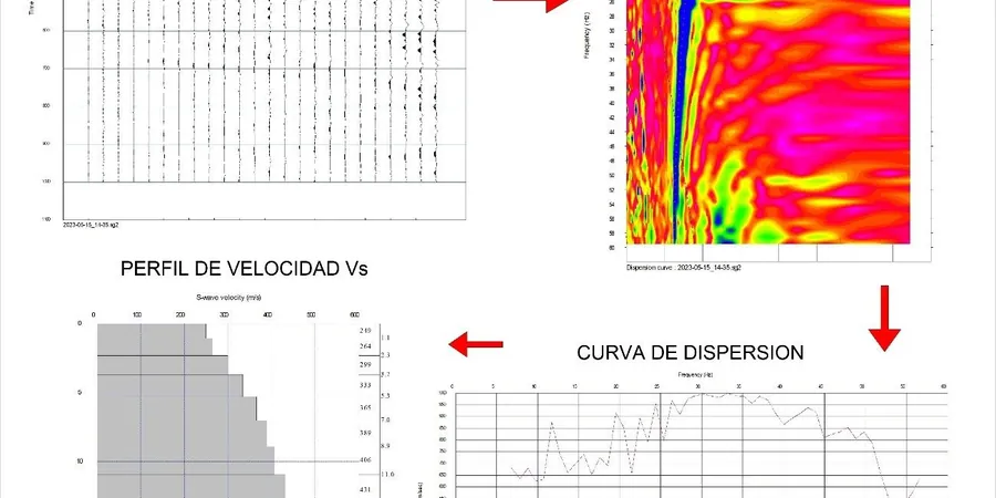
Local considerations
Around Wexford, one of the more common surprises is encountering a thin crust of desiccated clay over softer, normally consolidated silt, particularly on low-lying sites near the Slaney estuary. A MASW survey that is too short—say a 23-metre array—may sample only the stiff upper layer and overestimate VS30, leaving the softer material below undetected. We see this most often on greenfield sites where the top metre has been trafficked and dried out during summer months. The fix is straightforward: extend the array length to at least 46 metres and run a second spread perpendicular to the first to check for anisotropy. When the Vs contrast between layers exceeds 2:1, the inversion can become non-unique, so we constrain the model with a single borehole or CPT log. Overlooking this step has led to foundation designs that underestimate settlement on the softer silts, particularly under the sustained load of grain silos or warehouse racking.
Frequently asked questions
How much does a MASW survey cost for a typical house site in Wexford?
For a single-family dwelling site in County Wexford, a basic MASW survey (one or two lines) typically falls between €1.570 and €2.430, depending on array length and the number of spreads required. Sites with difficult access or dense vegetation may need additional clearing, which can influence the final figure. We provide a fixed-price quote after a desktop review of the site's geology and the proposed structure.
Is MASW accepted by Wexford County Council for planning applications?
Yes. MASW-derived VS30 values are accepted as part of the site ground investigation report, provided the testing is conducted by a competent geophysical contractor and the results are interpreted with reference to Eurocode 8. The council's planning department typically looks for a clear site classification (ground type A through E) and confirmation that the seismic design parameters match the foundation proposal.
Can MASW work on the boulder clays common around Wexford?
Boulder clay, or lodgement till, is one of the better materials for MASW because its stiffness generates strong, coherent surface waves. The main limitation is that large isolated boulders near the surface can scatter high-frequency energy, so we sometimes need a longer geophone array to capture the lower-frequency fundamental mode clearly. In those cases, we supplement the survey with a short seismic refraction line to identify the boulder field and mask its influence on the dispersion curve.